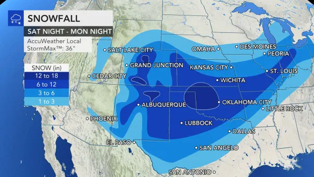
Governor Stitt has declared a state of emergency for all 77 counties in Oklahoma as the Sooner State prepares for an incoming snowstorm with low temps and blizzard-like conditions. Citing “extreme freezing temperatures and severe winter weather,” Stitt’s order says that it may be necessary to provide “mutual assistance … with respect to carrying out disaster emergency functions.” The order will expire in thirty days. Read the full order here.
After two months of relatively mild weather, Old Man Winter is visiting Oklahoma with a vengeance. Since the early morning hours of February 8, Creek County and surrounding areas have experienced freezing drizzle and light snow along with colder temperatures.
The National Weather Service has issued a winter storm watch from Sunday morning until Monday afternoon for Northeastern Oklahoma. Friday and Saturday are expected to be cold with snow flurries due to lake effect snow from Lake Oologah. Starting early Sunday morning we should see light snowfall with an accumulation of an inch or less. Heavy snow, along with gusty north winds, is expected to begin Sunday evening and continue until Monday afternoon, when the storm system moves out of Oklahoma.
NWS modeling data, which has been consistent for several days, shows a conducive set of conditions for a major winter storm. There is a deepening arctic air mass in place, and favorable dynamics to draw in moisture and produce lift over this cold air.
According to NWS discussions, this storm “has the feel of February 2011.” The latest prediction is 8-10 inches of snow, although the amounts could change as the system draws closer. The NWS will most likely issue a winter storm warning by Friday evening.
To make matters worse, another system will follow late Tuesday into Wednesday, spreading more snow in the area. However, the winds will not be as strong. Accuweather.com is reporting that close to 60% of the entire country will have snow or ice on the ground by next week.

People should bring pets indoors since air temps will be close to zero and the wind chill will approach 20 below zero.
There is much misunderstanding about the concept of “wind-chill.” Succinctly stated, the wind chill temperature is how cold people and animals feel when outside. The wind chill is based on the rate of heat loss from exposed skin caused by wind blowing cold air. As the wind speed increases, it draws heat from the body, thus lowering skin temperature and eventually the core body temperature.
Residents should make preparations for a worst-case scenario which would include power failures and roads that are impassable. It is always prudent to hope for the best but prepare for the worst.
Micah Choquette contributed to this story.


